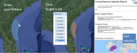
Hundreds of thousands of birds are injured or killed every year in fisheries around the world. This new website puts a wealth of information helpful in reducing bycatch right at the fingertips of those who need it most—fishermen, conservationists, and those promoting fishery sustainability. The web-based map tool—Seabird Maps & Information for Fisheries—provides information on seabirds in fisheries and can help to evaluate and reduce seabird bycatch. Intended to help fishers and fisheries managers determine what seabirds may be at risk in their geographic areas of interest, the tool also has broad appeal to anyone involved in fisheries improvement programs, seabird conservation, and marine spatial planning.
The map tool allows a user to quickly obtain a list of the species in your area of interest, find information related to seabirds themselves, on known bycatch issues, and factors that may indicate the risk posed to them by fishing.
Users of the map tool may:
Create fishery area maps and determine which birds occur there.
Review protected status, population size, and range maps.
Produce reports with information, such as diving depth and diet, that may indicate the risk posed by fishing gear.
Be directed to bycatch reduction resources.
Find additional online and literature sources.
See a brief introductory video: Putting Seabirds on the Map: Seabird Maps & Information for Fisheries
(https://www.youtube.com/watch?v=FAS8LKOoTSQ&list=PLsAsLroa7HAk2HAQK8pBGr...), or go directly to the website fisheryandseabird.info.
Featured Bycatch Species
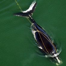
The small population of North Atlantic right whales is in danger of extinction.